

Search City, Amusement Park, Ski Area, or State Park
, Conditions
and °
in , you can expect with gusts to mph.
Wind: mph
Gusts: N/A
Feels Like: °
Humidity: N/A
Heat Index: °
Sunrise: 5/20 11:34 AM
Sunset: 5/20 11:34 AM
Dew Point: N/A
Sky Cover: %
Pressure IN: N/A
, Radar
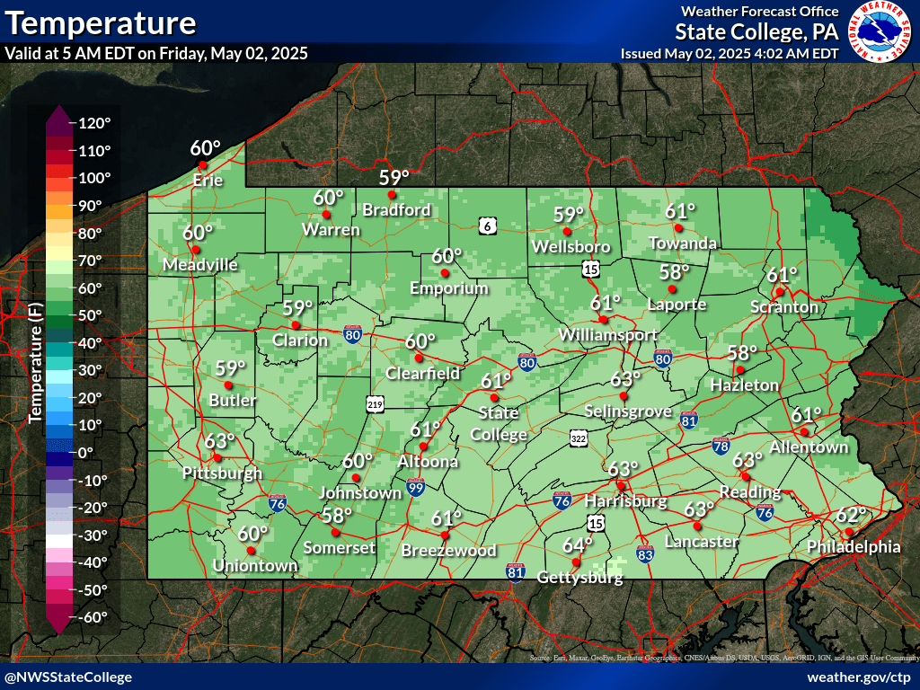
Current PA Temps.
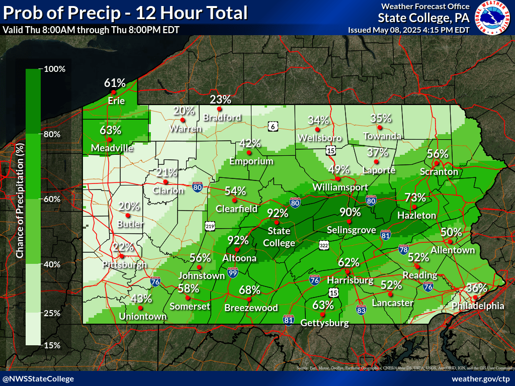
Current PA Precip. Chance
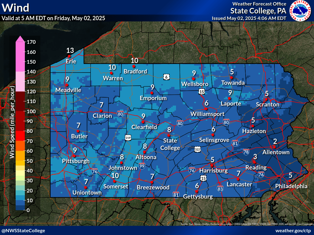
Current PA Winds
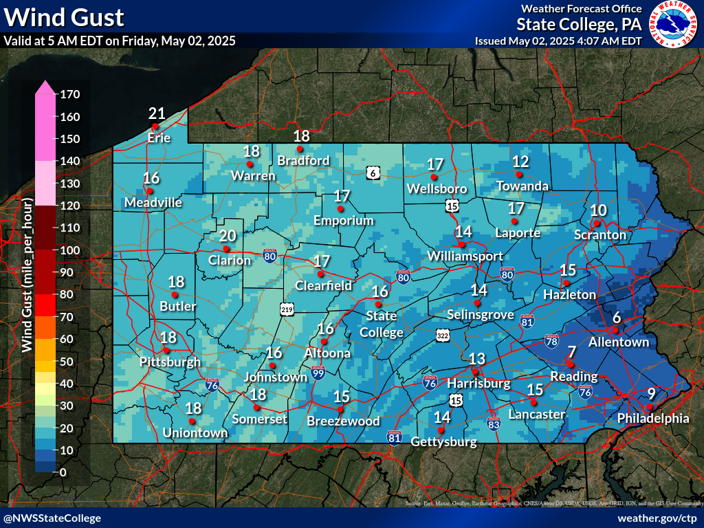
Current PA Wind Gusts
, Winds
, Precipitation
, Precip. Chance
, Snow Forecast
Avg. Temp. °
Avg. Wind mph
Avg. Temp. °
Avg. Wind mph
Avg. Temp. °
Avg. Wind mph
Avg. Temp. °
Avg. Wind mph
Hourly Winds
Hourly Temps.
Hourly Precip. Chance
Weather Mon Night
Temp. °
Precip. Chance
Conditions Mon Night
| Average Temps. | ° |
| Humidity | % |
| Precip. | in. |
| Snowfall | -" |
| Dewpoint | ° |
| UV Index |
Winds Mon Night
| Wind Direction | |
| Wind Gusts | mph |
| Avg. Winds | mph |
| Max Winds | mph |
| Min. Winds | mph |
| Feels Like | ° |
Monday Night 5/20/24
Weather Mon. Night
Temp. °
Precip. Chance
Conditions Mon. Night
| Average Temps. | ° |
| Humidity | % |
| Precip. | in. |
| Snowfall | 0" |
| Dewpoint | ° |
| UV Index |
Winds Mon. Night
| Wind Direction | |
| Wind Gusts | mph |
| Avg. Winds | mph |
| Max Winds | 0 mph |
| Min. Winds | mph |
| Feels Like | ° |
Temp. °
Precip. Chance
| Average Temps. | ° |
| Humidity | % |
| Precip. | in. |
| Snowfall | -" |
| Dewpoint | ° |
| UV Index |
| Wind Direction | |
| Wind Gusts | mph |
| Avg. Winds | mph |
| Max Winds | mph |
| Min. Winds | mph |
| Feels Like | ° |
Temp. °
Precip. Chance
| Average Temps. | ° |
| Humidity | % |
| Precip. | in. |
| Snowfall | -" |
| Dewpoint | ° |
| UV Index |
| Wind Direction | |
| Wind Gusts | mph |
| Avg. Winds | mph |
| Max Winds | mph |
| Min. Winds | mph |
| Feels Like | ° |
Temp. °
Precip. Chance
| Average Temps. | ° |
| Humidity | % |
| Precip. | in. |
| Snowfall | -" |
| Dewpoint | ° |
| UV Index |
| Wind Direction | |
| Wind Gusts | mph |
| Avg. Winds | mph |
| Max Winds | mph |
| Min. Winds | mph |
| Feels Like | ° |
Temp. °
Precip. Chance
| Average Temps. | ° |
| Humidity | % |
| Precip. | in. |
| Snowfall | -" |
| Dewpoint | ° |
| UV Index |
| Wind Direction | |
| Wind Gusts | mph |
| Avg. Winds | mph |
| Max Winds | mph |
| Min. Winds | mph |
| Feels Like | ° |
Temp. °
Precip. Chance
| Average Temps. | ° |
| Humidity | % |
| Precip. | in. |
| Snowfall | -" |
| Dewpoint | ° |
| UV Index |
| Wind Direction | |
| Wind Gusts | mph |
| Avg. Winds | mph |
| Max Winds | mph |
| Min. Winds | mph |
| Feels Like | ° |
Temp. °
Precip. Chance
| Average Temps. | ° |
| Humidity | % |
| Precip. | in. |
| Snowfall | -" |
| Dewpoint | ° |
| UV Index |
| Wind Direction | |
| Wind Gusts | mph |
| Avg. Winds | mph |
| Max Winds | mph |
| Min. Winds | mph |
| Feels Like | ° |
Temp. °
Precip. Chance
| Average Temps. | ° |
| Humidity | % |
| Precip. | in. |
| Snowfall | -" |
| Dewpoint | ° |
| UV Index |
| Wind Direction | |
| Wind Gusts | mph |
| Avg. Winds | mph |
| Max Winds | mph |
| Min. Winds | mph |
| Feels Like | ° |
| Day | Weather | Temp. | Feels Like |
|---|---|---|---|
| ° | ° | ||
| Monday Night 5/20/24 | ° | ° | |
| ° | ° | ||
| ° | ° | ||
| ° | ° | ||
| ° | ° | ||
| ° | ° | ||
| ° | ° | ||
| ° | ° |
Long Range Temperatures 6-10 Day Temps

Long Range Temperatures 8-14 Day Temps